LIST OF ONLINE DATA GATHERING TOOLS FOR SITE ANALYSIS

Site analysis is one of the preliminary
stages of design which focuses on the existing conditions of the site. In
practice, site analysis involves gathering of data, mainly a collection of
physical information of the location’s archaeology, geography, geology,
topography, and climate factors. These data gathering is important in order to
formulate a design concept, proper selection of materials, design solution
etc..
Here in this blogpost, I will
introduce you to the different sites that offers topographic information,
climate data, calculation, and other references that can be helpful for your
future projects and studies.
- ONLINE TOPOGRAPHIC MAP SURVEYING
- ONLINE CLIMATE DATA
- ONLINE INTERACTIVE MAP TOOL
- ONLINE CALCULATOR
- ONLINE GIS DATA
- ONLINE WATER DATA
ONLINE TOPOGRAPHIC MAP SURVEYING
Topographic map surveying is very
essential in landscape architecture design in order to determine the contour and
elevations of the site. Records of the site’s topography can generally
contribute in the design especially in analyzing the surface water run-off. Here
are the different online maps that offers topographic features.
1. NATIONAL MAPPING AND RESOURCE INFORMATION AUTHORITY (NAMRIA)

Download link: http://www.namria.gov.ph/download.php
NAMRIA is a government
agency in the Philippines under the Department of Environmental and Natural
Resources (DENR) that offers different mapping system and quality geospatial
information and services of the Philippines. In terms of topographic map surveying,
NAMRIA offers two major index map, set at 1:250,000 and 1:50,000 scale. All the
topographic map is downloadable online, and set in JPEG format.
2. Topographic-map.com

The Topographic-map.com offers heat map visualization of topographic map integrated with OpenStreetMap, OpenTopoMap, Esri/Topo, Esri/Imagery etc… The graduated tint color used in this map represents elevation and relief, overlapping with contour lines. Here, the graduated tint color from blue to green represents relatively low elevation while the graduated tint color from yellow to red represents high elevation. I recommend heat map topographic mapping in conducting macro analysis of the site.
3. OpenStreetMap

Website link: https://www.openstreetmap.org/
OpenStreetMap provides
specialty purpose maps that are usually display in different map layers such as
standard map, cycle map, transport map, and humanitarian. Each of the following
map layers uses specific map legends in order to emphasize the data according
to its physical mapping of linkages, cultural landmarks, and spatial
surroundings. Open Street Map also features online mapping that only requires
registration. For SKetchUp users, Open Street Map can export the data into
map.osm file, which can be imported into 3-D model inside SketchUp. Here, you
will need a plugin that can import map.osm file inside SketchUp. You can check
out some tutorials for Open street map below.
Tutorials:
Plugins for SketchUp:
4. OpenCycleMap

Website link: https://www.opencyclemap.org/
Similar to OpenStreetMap,
OpenCycleMap offers almost the same viewing options with the emphasis on roads
or transport linkages. This can serves as a reference for cycling road
activities. One of the unique feature of the site is the ‘Transport Dark’ layer
with clear visibility of road, streets, path walks and other transport
linkages.
5. Google Maps

Website link: https://www.google.com/maps/
Google map is one of the
most popular online map surveying available via internet with topographic
features. You can view the map as general rendered map or satellite viewing. In
terms of topographic view, you can extensively zoom the map with a limited
range of 20 meter contour interval. If you want to know how to adjust to
contour interval from 20 meters to 5 meters with google map as a reference, you
can check my tutorial below.
Tutorials:
6. Thunderforest
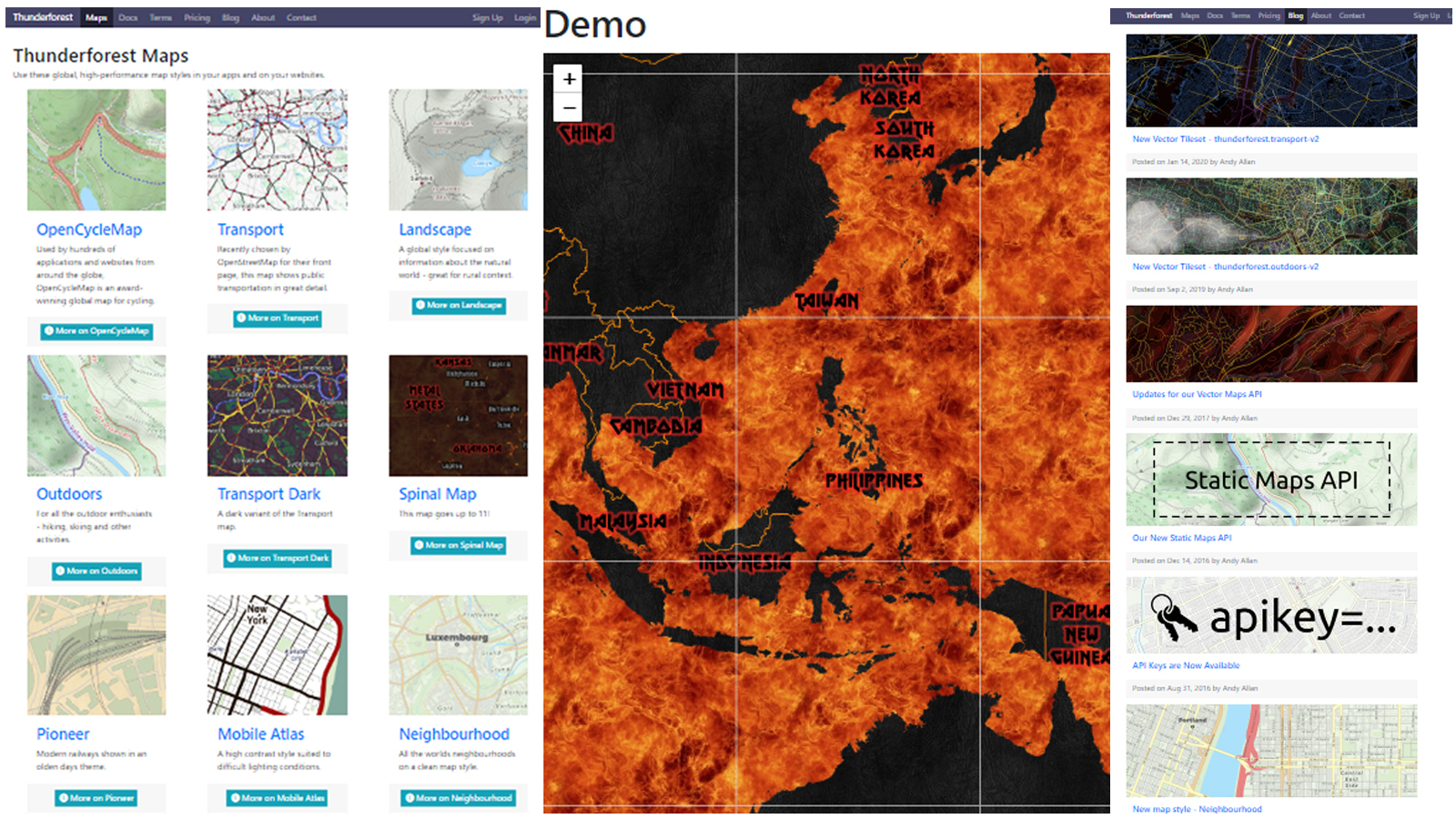
Website link: https://www.thunderforest.com/
Thunderforest offers a
wide array of topographic map style options such as Open cycle map, Transport,
Landscape, Outdoors, Neighborhood, Pioneer, Mobile Atlas, Transport Dark and Spinal
map. In terms of visualization, the Spinal map encompass the high quality of artistry
with Gothic style presentation. It is interesting to note that the author of
this site Mr. Andy Allanis is also the same person who created the OpenCycleMap
and one of the contributor of OpenStreetMap.
7. OpenTopoMap

Website link: https://opentopomap.org/
Open Topo Map produce a
high quality map render of classic topographic map style for general use. It
has a very simple approach in terms of map style but reach in topographic and physical
information. The Map data used in Open Topo Map is generally integrated to Open
Street Map and SRTM as contributor. You can check the map legend of the site by
clicking the ‘About’ menu at the main tab.
8. United States Geological Survey (USGS)

Map view: https://ngmdb.usgs.gov/topoview/viewer/#4/40.01/-100.06
The
United States Geological Survey is a scientific agency of the United States
government. The scientists of the USGS study the landscape of the United
States, its natural resources, and the natural hazards that threaten it. USGS
topo maps serves as the documentation of the changing geography of the United
States. The latest version of USGS topo view includes both current and
historical maps.
9. Ordnance Survey (OS)

Website link: https://osmaps.ordnancesurvey.co.uk/
Ordnance Survey (OS) is
the national mapping agency for Great Britain that offers available online map
and printed maps. The OS map contains a detailed topographic feature of the
United Kingdom, comprising of large-scale representation of features in the
real world, such as buildings and areas of vegetation. There are different
selections of map layers inside the application such as Standard, Aerial,
National Park Pathways, Greenspace, National Cycle Networks, OS Leisure Maps
and Aerial 3D (some of this option is free with seven day trial).
10. Natural Resources Canada (NRCan)

Map view: https://open.canada.ca/en/open-maps
The Department of Natural
Resources, operating under the FIP applied title Natural Resources Canada
(NRCan), is the ministry of the government of Canada responsible for natural
resources, energy, minerals and metals, forests, earth sciences, mapping and
remote sensing. There are a wide variety of map options available in NRCan that
focus mainly on Canada’s physical and natural resources, energy resources,
agriculture, hazardous area, zoning, projects etc.. In order to access the map,
go to (1) open data> https://open.canada.ca/en/open-data
(2) open maps> https://open.canada.ca/en/open-maps
(3) Select any available map ‘New and updated maps’ or ‘map gallery’.
11. SwissTopo

Website link: https://map.geo.admin.ch/
SwissTopo maps are
produced by the Federal Office of Topography, part of the Federal Switzerland's
national mapping agency. It is interesting to note that Swiss Topo are widely
regarded as the finest online map in the world in terms of its quality,
accuracy and artistry. Under the Geocatalog option, you can change the mapping
visualization according to its land use plan, natural environment, population
and economy. Maps displayed option in this map is very useful for navigation,
linkages, and landmarks. The Swiss Topo delivers a 3D-like depth map or a
raised-relief map that visualize existing terrain, buildings, roads, body of
water etc. realistically under ‘aerial imagery’ and ‘3D switch’ options. There
is also a tool wherein you can put a marker and measure the area in the map,
almost similar to Google Earth.
12. Geoportail

Map view: https://www.geoportail.gouv.fr/donnees/litto3d
Géoportail is a
comprehensive web mapping service of the French government that publishes maps
and geophysical aerial photographs from more than 90 sources for France and its
territories. Geoportail map offers topographic maps of France with both
classical contours and 3D perspective.
13. Geosciences Australia

Website link: https://www.ga.gov.au/scientific-topics/national-location-information/topographic-maps-data/topographic-maps
Geoscience Australia is an
agency of the Australian Government. It carries out geoscientific research. The
agency is the government's technical adviser on all aspects of geoscience, and
custodian of the geographic and geological data and knowledge of the nation.
You can access the topographic maps in details with various scale available
with 1:50,000, 1:100,000, 1:250,000 and 1:1 million scale. You can download the
map of different selected areas of Australia in tif format.
14. Maps of the World

Website link: http://www.maps-of-the-world.net/
This site provides different
types of maps in a macro level. Since the available map here is set in a macro
view, you can use the data for macro analysis particularly in urban planning
and environmental planning. The following available maps includes administrative
map, physical map, topographic map, climate map, economic map, city map, road
map, railway map, relief map, ecological map etc… You can download each map in
JPEG format.
ONLINE CLIMATE DATA
1. Project NOAH

Website link: http://noah.up.edu.ph/
The Nationwide Operational
Assessment of Hazard or Project NOAH is the government’s program for disaster
prevention and mitigation. In conduction site analysis, the records of flooding
in the Philippines which are available in this site can be used as a reference
specifically for mapping flood-prone areas. Records of rainfall intensity can
also be found in this site which is also valuable data especially in
determining surface run-off coefficient.
2. PAGASA

Website link: http://bagong.pagasa.dost.gov.ph/
The Philippine
Atmospheric, Geophysical and Astronomical Services Administration or PAGASA is one
of the attached agencies of the Department of Science and Technology (DOST)
under its Scientific and Technical Services Institutes, which is mandated to provide
protection against natural calamities. One of the new feature of this site is
the map layer option, which provide information regarding the country’s current
weather forecast, temperature, precipitation, winds, rainfall, tropical cyclone
etc.. The weather forecast data available in this site can be useful in
providing essential information for site analysis.
Other international website that
can provide climate and weather forecast data includes National Oceanic and
Atmospheric Administration (NOAA) and Climate-Data.org
3. National Oceanic and Atmospheric Administration (NOAA)

Website link: https://www.ncdc.noaa.gov/
4. Climate-Data.org

Website link: https://en.climate-data.org/
ONLINE INTERACTIVE MAP TOOL
Using online interactive map
tool, many planners and researchers will enable to organize and document their
map-based data as well as create personalized map visualization for
presentation. Here is my short list of different free interactive map tools
available online.
1. Snazzy Map

Website link: https://snazzymaps.com/
Snazzy Map typically an
online map tool that can enhance your map image visually. Equipped with
different artistic styles for map visualization, you can also make your own
customized map rendering using Snazzy Map. Downloading the map image from the
site is limited to 10 downloads per day. This online map tool requires online
registration in order to access the full capacity of the product.
2. ZeeMaps

Website link: https://www.zeemaps.com/
ZeeMaps is an
enterprise-class mapping service which allows you to easily create, publish and
share interactive maps. In terms of construction and design profession as well
as real estate agents, this interactive map tool enables the users to easily
document their projects, update sales development, update research progress and
conduct site inventory, through site inventory mapping. This online map tool
can be access through online registration with free and paid version. The free
version of this application allows you to share and publish your works, but
with a limited number of 100 views only. For ZeeMaps tutorial, see link below.
Tutorials:
3. Mapme

Website link: https://app.mapme.com/
Mapme functions as a free
mapping service, similar to Zeemaps wherein you can customized and move the
location markers. One of the fascinating feature here is that you can upload
multiple images in one location. However, publishing and sharing is only
available for Premium users, which technically for paid version. You can check
out some tutorials about Mapme, see link below.
Tutorials:
ONLINE CALCULATOR
1. Rational Equation Calculator

Website link: Rational Equation Calculator
In
the field of Landscape Architecture, designing a drainage plan requires a
specific pipe size and inlet diameter size which technically based its dimensions
on the peak flow-discharge value of extreme rainfall events. Thus, the peak
discharge value can serves as a reference in determining the pipe size and
inlet size needed for drainage installation. Here, Rational Equation Calculator
is a free online calculator that determines the peak discharge value. In using Rational
Equation Calculator, you can assign specific value on Rational runoff
coefficient. You can use the index of surface Runoff Coefficient as a reference
which is also available in the application. Rainfall intensity value can be
determine by obtaining data from different any international or local meteorology
website. If you’re site is in the Philippines, you can refer to Project NOAH or
PAGASA website as reference to obtain data with regards to Rainfall intensity value.
In order to assign specific value for the drainage area, you can refer to the existing
area of your site as your primary data. If you want to explore more fluid flow calculation,
you can visit their main website, see link below.
Main Website link:
2. CSG Network

Website link: http://www.csgnetwork.com/
CSG Network offers a wide
range of online applications, converters, calculators, charts, and general
information. In order to open a specific converters and calculators, go to the
site and open the ‘converters and calculators’, select a specific field
relevant to your profession, for instance ‘construction’, then choose your
desire converters and calculators that can contribute to your design.
ONLINE GIS DATA
1. PhilGIS

Website link: http://philgis.org/
PhilGIS is a collection of
GIS data of the Philippines with several contributors from different National
government agencies such as DENR, DPWH, PAGASA, TESDA, etc... There is also
several downloadable links of different GIS Software in the site.
ONLINE WATER DATA
1. Environmental Management Bureau

Website link: Water Bodies in The Philippines
The Environmental
Management Bureau (EMB) under the Department of Environment and Natural
Resources (DENR) is a government agency in the Philippines with its primary objective
is to protect, restore, and enhance environmental quality. Their website offers
valuable data with regards to classification of water bodies in the
Philippines, water quality management area and other government programs. Based
on their data, water bodies in the Philippines are classified according to its
beneficial use to human, water quality and the adjacent area. For more
information, you can visit the EMB website, see link below.
Main Website link:
Thank you for reading.
Comments
Post a Comment